Saturday, June 15, 2013

The end of an era, or eon, ok maybe an age at best.

When I first started this blog I had just moved to a new town where I didn’t know anyone but my boyfriend. I was taking 17 freshman level undergraduate credits at a new school (five of which were online) and I was not working a job.  Needless to say, this was an outlet for not only being social, but a way to write about my new found love of Geology. Many of the bloggers I followed previous to starting were women in academics, either as professors or graduate students and many posted under pseudonyms.  So, I followed this trend in setting up my blog separate from my personal accounts.  While I wasn’t so busy, it was much easier for me to keep up with semi regular-posting.


In the past two and a half years I have added a second major (chemistry) gained three jobs (tutor, teaching assistant, research assistant) and not to mention a bit of a social life and my blog has been neglected. The one thing I do know is that I still find time to check my personal google+ account and post fairly often. Because of this I have decided to restart the blog engine, so to speak, back on my personal account. I love what I do and don’t feel the need to be anonymous anymore.  So I hope you join me on my new journey at Clasticphile (yeah a little different title, but I still like clastics ;) 

Also, here is a picture of some lazy cats.
I'm touching you, I'm touching you, does this bother you?

Wednesday, January 30, 2013

Procrastination and Airplanes

A new post you say?  A new post I say!  Indeed I have been horrible at updating this thing, but tonight (due to procrastination of homework and a need to look at pretty pictures) I present my own "Airliner Chronicles" a la +Garry Hayes style.

These photos were taken on a flight from Grand Junction, CO to Denver, CO. They are a little blurry due to the fact that they were taken with my phone, and I was behind the wing, but I still managed to get some alright shots.

This is the view within a few minutes of leaving Grand Junction.

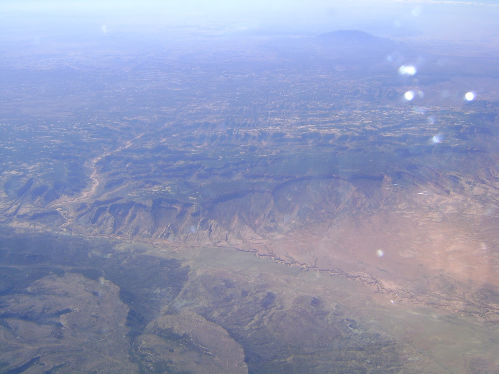
The bright white area is an old alien landing strip, or so I've been told.

Actually, that flat white landform under the wing is the Grand Mesa.  It is made up of a series of basaltic lava flows which originated to the east from fissure style eruptions.  The flows range in age from 9-11 Ma and overlie thousands of feet Cenozoic to Mesozoic rocks.  Basalt slump blocks flank the edges of Grand Mesa creating lakes which are used for recreation. At heights averaging around 10,000ft, it towers above the Grand Valley in which Grand Junction lies at 4,500 ft.  Why is everything so grand around here?  Well it is home to the confluence of the Grand River (now named the Colorado)and the Gunnison River. Recently (within the last couple years) river gravels have been discovered directly under the lava flows. The origin of these are currently subject to debate as to whether they belong to an ancestral Colorado River, Gunnison River or possibly both!  (At the beginning of January I was in Arizona at the Arizona LaserChron Center processing a sample from these gravels. Unfortunately with the new semester starting I have yet to review the data.)

Heading further east, we encounter the West Elk Mountains.

And a bit less blurry photography as well!

In the foreground lies Mt. Gunnison with several other peaks in the background.  These tell a story of Oligocene volcanic activity in Colorado and are made up of several volcanic tufts and breccias which overlie the same sedimentary rocks as the Grand Mesa.  Glacial activity accentuated the peaks into the sharp aretes and horns we see today, although they are much less dramatic than the San Juan Mountains which hold the same history.

Onward to South Park!  No, not the TV show, but the actual South Park in Colorado.

Look at the friendly places everywhere and humble folks without temptation!

South Park is a synclinal feature and is one of the high basins in Colorado along with North Park, Middle Park and the San Luis Valley.  South Park sits between the Front Range to the east and the Sawatch Range to the west which contains several of Colorado's 14ers and boasts the headwaters of the Arkansas River.

While the Arkansas flows south out of the valley, we head north and eastward towards Denver to find the beginnings of a new river, the South Platte.

Look! Racing Stripes!

It is here we encounter the boundary between the physiological divisions of the Southern Rocky Mountains and the Great Plains. The displacement in this region along the many faults reaches upwards of 7,000 feet in places. The long ribbons of rock were formed when the Rocky Mountains were uplifted relative to the Great Plains, shoving any rock covering them upwards as well.  Chiefly made of the Fountain Formation which is eroded remains of the ancestral Rocky Mountains, these hogbacks run for miles along the Front Range and include sites such as Red Rocks amphitheater in Morrison, Colorado and the Flatirons in Boulder.  The break in these ridges about midway in the picture are due to the South Platte River exiting the Rocky Mountains an creating a path out onto the Great Plains.

This brings us to our last photo.

Hey, how'd it get so flat?

Here the plain-ness (if that is a word, which I'm sure it isn't) of the Great Plains is seen in full view.  The ridge of snow capped peaks in the far background is our rather tiny looking Rocky Mountains.  Every time I drive towards the mountains I can't help but wonder what the first pioneers thought as the towering behemoths of the Rockies slowly crept into view. Covered with loess deposits and Cretaceous marine rocks, among others, it is hard to escape the flatness of the Denver Basin area as compared to the Rocky Mountains.

This flight was just one leg of a trip to Philadelphia so next time, we shall continue eastward!

Wednesday, July 18, 2012

Why I love Flying. (hint, it's all about the window seat!)

I have flown a lot over the course of my life, probably more than most folks who don't have to travel for a job.  I have always loved occupying the window seat.  Being able to look down at buildings and cars and the landscape was always magical, but it wasn't until getting into geology that I began to really appreciate flying in a window seat.

Seeing geologic structures from the air makes me feel like a superhero (Geology Girl! photographing plunging synclines in a single shot!), so now I carry a camera whenever I'm on a flight. Here is a series of the Colorado Plateau from Phoenix, AZ to Grand Junction, CO taken upon returning from lab work at University of Arizona's LaserChron Center.

Much thanks to Google Earth for helping me locate the photos!

Looking towards west towards Navajo National Monument in Arizona with Navajo Mountain peaking out in the background.
Navajo Mountain is actually just over the border in Utah. It shares a similar history as the Henry Mountains and the La Sal Mountains as they are all intrusive laccoliths within the Colorado Plateau.

The southern end of Monument Valley in Arizona. Boot Mesa is in the center of this photo.

Oljato-Monument Valley. Oljato Mesa is in the center of the photo, and Train Rock is present on the right.

The Permian DeChelly Sandstone is responsible for the large vertical cliffs of the buttes, mesas and spires within Monument Valley. The underlying shales are Permian in age as well and are of the Organ Rock Formation.  The formations overlying the DeChelly are the Triassic Moenkopi and Chinle formation.

Here is a link to an amazing Gigapan (read really detailed large photograph) of  Monument Valley  by Geologist Ron Schott.
According to Utah.com, Goosenecks State Park covers 300 million years of time through the rocks of the canyons.  Here is another Gigapan by Ron Schott looking into the goosenecks.


Goosenecks State Park in southern Utah.

Looking northwest towards the entrance to the Needles district of Canyonlands Nation Park in Utah.
This valley holds the road into the entrance of the Needles district.  You can find petroglyphs on the canyon walls before reaching Canyonlands.  Below is a shot of Newspaper Rock taken on my last trip to Moab.
Petroglyphs!

Looking northwest at the La Sal Mountains- Mt. Peale, Mt. Tukuhnikivatz and Mt. Mellenthin
As mentioned above, the La Sal Mountains are an exposed laccolith. They sit on the eastern edge of Utah on the Colorado border.  Edward Abbey wrote about Mt. Tukunikivatz in his book Desert Solitaire.


Overlooking Ute Canyon in the Colorado National Monument with Grand Junction and the Bookcliffs in the background.
Looking north towards the East Entrance of CNM and the Serpents Trail with Grand Junction in the Background.
Oh give me a home...where the monocline roam...or something like that.   Colorado National Monument is part of a huge monocline (which I'm pretty sure I have mentioned before).  In fact, there is a picture of the Monument on the linked page.  Anyway, with all the traveling this summer, it was sure nice to come home to beautiful weather and clear enough skies to take these couple pictures.  The last time I flew from Arizona, it was dark before hitting Utah!

Saturday, April 28, 2012

100 things to see: Geology related.

Hello dear readers!


I found this meme via Geotripper and decided to give it a whirl.  Here is a list of 100 geology related sites to see. The ones in bold I have seen.Though shome of these I have seen in photos or video, I would jump at the chance to see some in person. Hopefully in the next year I can check off some more!\


1. See an erupting volcano
2. See a glacier
3. See an active geyser such as those in Yellowstone, New Zealand or the type locality of Iceland
4. Visit the Cretaceous/Tertiary (KT) Boundary. Possible locations include Gubbio, Italy, Stevns Klint, Denmark, the Red Deer River Valley near Drumheller, Alberta.
5. Observe (from a safe distance) a river whose discharge is above bankful stage6. Explore a limestone cave. Try Carlsbad Caverns in New Mexico, Lehman Caves in Great Basin National Park, or the caves of Kentucky or TAG (Tennessee, Alabama, and Georgia)
7. Tour an open pit mine, such as those in Butte, Montana, Bingham Canyon, Utah, Summitville, Colorado, Globe or Morenci, Arizona, or Chuquicamata, Chile.
8. Explore a subsurface mine.
9. See an ophiolite, such as the ophiolite complex in Oman or the Troodos complex on the Island Cyprus (if on a budget, try the Coast Ranges or Klamath Mountains of California).
10. An anorthosite complex, such as those in Labrador, the Adirondacks, and Niger (there's some anorthosite in southern California too).
11. A slot canyon. Many of these amazing canyons are less than 3 feet wide and over 100 feet deep. They reside on the Colorado Plateau. Among the best are Antelope Canyon, Brimstone Canyon, Spooky Gulch and the Round Valley Draw.
12. Varves, whether you see the type section in Sweden or examples elsewhere.
13. An exfoliation dome, such as those in the Sierra Nevada.
14. A layered igneous intrusion, such as the Stillwater complex in Montana or the Skaergaard Complex in Eastern Greenland.
15. Coastlines along the leading and trailing edge of a tectonic plate (check out The Dynamic Earth - The Story of Plate Tectonics - an excellent website).
16. A gingko tree, which is the lone survivor of an ancient group of softwoods that covered much of the Northern Hemisphere in the Mesozoic.
17. Living and fossilized stromatolites (Glacier National Park is a great place to see fossil stromatolites, while Shark Bay in Australia is the place to see living ones)
18. A field of glacial erratics
19. A caldera
20. A sand dune more than 200 feet high

21. A fjord
22. A recently formed fault scarp
23. A megabreccia
24. An actively accreting river delta
25. A natural bridge
26. A large sinkhole
27. A glacial outwash plain

28. A sea stack
29. A house-sized glacial erratic
30. An underground lake or river
31. The continental divide
32. Fluorescent and phosphorescent minerals
33. Petrified trees

34. Lava tubes
35. The Grand Canyon. All the way down. And back.
36. Meteor Crater, Arizona, also known as the Barringer Crater, to see an impact crater on a scale that is comprehensible
37. The Great Barrier Reef, northeastern Australia, to see the largest coral reef in the world.
38. The Bay of Fundy, New Brunswick and Nova Scotia, Canada, to see the highest tides in the world (up to 16m)
39. The Waterpocket Fold, Utah, to see well exposed folds on a massive scale.
40. The Banded Iron Formation, Michigan, to better appreciate the air you breathe.
41. The Snows of Kilimanjaro, Tanzania,
42. Lake Baikal, Siberia, to see the deepest lake in the world (1,620 m) with 20 percent of the Earth's fresh water.
43. Ayers Rock (known now by the Aboriginal name of Uluru), Australia. This inselberg of nearly vertical Precambrian strata is about 2.5 kilometers long and more than 350 meters high
44. Devil's Tower, northeastern Wyoming, to see a classic example of columnar jointing
45. The Alps.

46. Telescope Peak, in Death Valley National Park. From this spectacular summit you can look down onto the floor of Death Valley - 11,330 feet below.
47. The Li River, China, to see the fantastic tower karst that appears in much Chinese art
48. The Dalmation Coast of Croatia, to see the original Karst.
49. The Gorge of Bhagirathi, one of the sacred headwaters of the Ganges, in the Indian Himalayas, where the river flows from an ice tunnel beneath the Gangatori Glacier into a deep gorge.
50. The Goosenecks of the San Juan River, Utah, an impressive series of entrenched meanders.
51. Shiprock, New Mexico, to see a large volcanic neck
52. Land's End, Cornwall, Great Britain, for fractured granites that have feldspar crystals bigger than your fist.
53. Tierra del Fuego, Chile and Argentina, to see the Straights of Magellan and the southernmost tip of South America.
54. Mount St. Helens, Washington, to see the results of recent explosive volcanism.
55. The Giant's Causeway and the Antrim Plateau, Northern Ireland, to see polygonally fractured basaltic flows.
56. The Great Rift Valley in Africa.
57. The Matterhorn, along the Swiss/Italian border, to see the classic "horn".
58. The Carolina Bays, along the Carolinian and Georgian coastal plain
59. The Mima Mounds near Olympia, Washington
60. Siccar Point, Berwickshire, Scotland, where James Hutton (the "father" of modern geology) observed the classic unconformity
61. The moving rocks of Racetrack Playa in Death Valley
62. Yosemite Valley
63. Landscape Arch (or Delicate Arch) in Utah

64. The Burgess Shale in British Columbia
65. The Channeled Scablands of central Washington
66. Bryce Canyon
67. Grand Prismatic Spring at Yellowstone
68. Monument Valley
69. The San Andreas fault
70. The dinosaur footprints in La Rioja, Spain
71. The volcanic landscapes of the Canary Islands
72. The Pyrennees Mountains
73. The Lime Caves at Karamea on the West Coast of New Zealand
74. Denali (an orogeny in progress)
75. A catastrophic mass wasting event
76. The giant crossbeds visible at Zion National Park
77. The black sand beaches in Hawaii (or the green sand-olivine beaches)
78. Barton Springs in Texas
79. Hells Canyon in Idaho
80. The Black Canyon of the Gunnison in Colorado
81. The Tunguska Impact site in Siberia
82. Feel an earthquake with a magnitude greater than 5.0.
83. Find dinosaur footprints in situ84. Find a trilobite (or a dinosaur bone or any other fossil)
85. Find gold, however small the flake
86. Find a meteorite fragment
87. Experience a volcanic ashfall
88. Experience a sandstorm
89. See a tsunami
90. Witness a total solar eclipse
91. Witness a tornado firsthand. (Important rules of this game).
92. Witness a meteor storm, a term used to describe a particularly intense (1000+ per minute) meteor shower
93. View Saturn and its moons through a respectable telescope.
94. See the Aurora borealis, otherwise known as the northern lights.
95. View a great naked-eye comet, an opportunity which occurs only a few times per century
96. See a lunar eclipse
97. View a distant galaxy through a large telescope

98. Experience a hurricane
99. See noctilucent clouds
100. See the green flash


Well, I have been close on a few of them (felt an earthquake of 4.4, but not above 5 and saw Dinosaur footprints in Moab and Colorado instead of Spain) but there are plenty of items on that list for me to strive for!


One more week of school, then one day of finals (all of them happen to be on the same day) then off to New Mexico for the ASG Rocky Mountain Section meeting!


Yeeehaw!

Monday, March 26, 2012

Ye Olde Coal Mine

I can't believe it has been so long since my last post. I'm going to make a point to post something at least once a month (especially with the backlog of photos from trips in my possession!)

Todays post is brought to you by PBF's suggestion to go out and find the old Bookclif Mine and reminants of the town of Carpenter, Colorado.  This was a great excursion for the both of us between the geology of the area (for me) and the engineering of the old buildings (for PBF).

We parked where PBF's truck, Black Betty, could no longer trek.  Here is the view looking into the hills. You can faintly see the line where the trail runs up to the mine on the left.

Looking up toward the mine, which is hidden behind a hill.
Only walking a short distance, we came upon this retaining wall.  It looked to be built from fallen sandstone of the Mt. Garfield Formation above.

This probably spans 20 feet or so.

Close up of a drainage/tunnel entrance?
Pretty awesome engineering in the building of an arch!

Just up from the retaining wall was this block of flaggy to fissile siltstone weathering away.

PBF surveying the rock from above.
 We continued up the road to find a flattish area with some debris.

Rusted out metal door to something.
 Then entered upon this!

Wall of a domicile with wooden beams in place.
The far corner has some sort of pipe coming out of the wall.
 Then a bit further upwards, through much coal debris (of which my little camera would not take a decent picture.
That smallish grey smudge is coal. I promise.
Finally up to the mine entrance itself.

Taadaa! The entrance!
A closer look into the deep!  Ok well kind of.
 On the way back we found a block of sandstone (probably from the Mt. Garfield Fm.) which was tagged and painted over at some point.  It is possibly displaying some hummocky cross-stratification, which is evidence of hurricanes in Colorado's past!

Identification possible through your support and the support
of GEOL 444, Sedimentology and Stratigraphy.
 Once back at Black Betty we wandered a bit and found possible glass remains from the town. These were decidedly so due to the type and thickness of the glass which is not found today.

As well as an old shoe in the shadows.

The Bookcliff Mine was served by the Little Book Cliff Railway which was in operation for 36 years before shutting down.

So there is the Bookcliff Mine adventure!  Well a brief incantation of it anyway. I have a backlog of photos from Arizona and Moab to go through so until next time! Rock on!

Monday, November 28, 2011

Black Friday Roadtrip

Inspired by a post over at Garry Hayes over at Geotripper, I decided to post some of my favorite scenery along I-70 between Denver and Grand Junction. PBF and I spent Black Friday returning to Grand Junction after visiting family in Denver for Thanksgiving. In my opinion, a much better way to "spend" Black Friday!  And because I forgot to bring a camera, Google Street View will be assisting in the photos.

This water wheel (faint in center) outside Idaho Springs was built in 1896.  They had it covered with a big jack'o'lantern left over from Halloween of which I did not manage to get a picture.

Colorado's rich mining history has traces left along the sides of the highway.  Here is a tailing pile just west of Idaho Springs

The approach to Eisenhower Tunnel.  This amazing feat of engineering takes one over a mile and a half through a mountain from the Atlantic watershed to the Pacific watershed.


Nothing like some high elevation sedimentary rocks. These are located up near the top of Vail Pass

Dipping layers southwest of Vail, CO 


Steeply dipping layers just a few miles down from the last photo. This is just west of Wilmor Lake in the Eagle Basin. This is easily one of my favorite roadcuts
I can't tell you how great of timing the Google Van had in capturing a train running through debris from what was one of the many rock slides which plague Glenwood Canyon.  
The Eagle Basin is home the town of Gypsum, Colorado. The city is aptly named due to the extensive gypsum mining operation. The layers that were neatly organized in the last few photos are seen here super deformed due to the "flow" of gypsum.


Though not as well publicized for rock falls, DeBeque Canyon has it's share of lesser stable rocks.  This triangular on in the middle of the screen is one of my favorites. Though the rock itself is a well cemented sandstone, the rocks holding it up are close to silt and mudstone.


There is a brief highlight of how I spent my Black Friday. Much more fun than shopping!

Sunday, November 6, 2011

Legos!

I just had to share this series of Lego creations I found on the internet today.


Ok, you may return to your regularly scheduled Sunday night!